The Amazon Basin - sometimes called Amazonia - was formed over 10 million years ago.
Physical Geography
 15 million years ago, the Amazon River flowed from East to West, emptying into the Pacific Ocean. When the South American continent collided with another tectonic plate, the Andes Mountains were formed. The formation of this mountain range effectively blocked the path of the Amazon and caused inland seas to become freshwater lakes causing a dramatic change to the environment. The direction of the river was gradually reversed (from East-West to West-East) until it reached the Atlantic Ocean 10 million years ago.
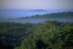
Today, the river is 6,750 km (4,080 miles) in length and supplies 20 percent of the Earth's freshwater while the rainforest covers a staggering 6,475,000 sq. km (2,525,250 sq. miles). A view of the rainforest canopy is show above.
The area spans a total of nine South American countries: Brazil, Guyana, Venezuela, Surinam, French Guiana, Columbia, Ecuador, Bolivia and Peru.
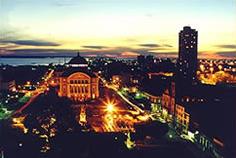
There are three major cities in the region: Belém and Manaus (pictured right) in Brazil and Iquitos in Peru. Belém was given city status in 1665 and is a trading city whose development was accelerated by the rubber boom. Today it trades products such as Brazil nuts and wood.
Manaus is a port for ocean-going ships and an important manufacturing centre. It also has a large airport.
The Peruvian city of Iquitos expanded rapidly with the rubber boom like Belém but then suffered a decline. However, recent years have seen an increase in population and wealth.
Climate
The climate of the area is tropical with daytime temperatures typically ranging from 25 to 28 degrees celcius throughout the year. Rainfall is heavy - between 120 and 240 inches of rain annually while relative humidity stays high all year. It is these warm and damp conditions that have lead to the dense vegetation of the rainforest.
Human Geography
Much of the rainforest is impenetrable. For this reason the Amazon Basin area is very sparsely populated and there are few large towns.
The native people have farmed the land for centuries harvesting Brazil nuts, cocoa, vanilla oil and natural rubber. This sustainable farming does not damage the rainforest but recent large scale activities such as logging and ranching have destroyed some areas. There are now tighter controls in place to limit the environmental damage that can be made by such industries.